


trans les arcs

essius
User
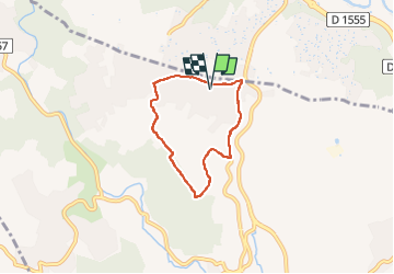

Length
5.3 km

Max alt
209 m

Uphill gradient
106 m
Km-Effort
6.7 km

Min alt
131 m

Downhill gradient
105 m
Boucle
Yes
Creation date :
2025-06-17 07:23:35.001
Updated on :
2025-06-17 08:45:31.052
1h16
Difficulty : Easy

FREE GPS app for hiking
 SityTrail
IGN / Geographical institutes
SityTrail Plus
The world is yours!
About
Trail Walking of 5.3 km to be discovered at Provence-Alpes-Côte d'Azur, Var, Les Arcs-sur-Argens. This trail is proposed by essius.
Positioning
Country:
France
Region :
Provence-Alpes-Côte d'Azur
Department/Province :
Var
Municipality :
Les Arcs-sur-Argens
Location:
Unknown
Start:(Dec)
Start:(UTM)
296028 ; 4817810 (32T) N.
Comments